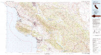
1981 Map of San Luis Obispo
USGS Topo · Published 1981About this map
The Santa Lucia Range and La Panza Range dominate this coastal landscape, where the Southern Pacific railroad threads through the interior valleys to reach the urban center of San Luis Obispo. In the early 1980s, the region shows a complex mix of institutional and recreational land use, from the Camp San Luis Obispo National Guard Res to the sprawling Pismo Dunes State Vehicular Recreation Area. Along the coast, prominent maritime landmarks like Morro Rock and Point San Luis anchor the shoreline, while inland, the Salinas River and major reservoirs like Santa Margarita Lake and Lopez Lake provide critical water resources. This survey details the transition from the concentrated residential areas of Atascadero and Grover City to the wide expanse of the Carrizo Plain, illustrating the geographic diversity of the Central Coast.
Find a feature on this map
98 named features on this map. Tap any name to fly to it.
Don’t see what you’re looking for? This feature index may not catch every label — zoom into the map to look around manually.
Map Details
Editions of this 1981 San Luis Obispo Map
3 editions found
Other maps of this area

1897 · Port Harford
USGS Topo · 1:62,500

1897 · San Luis Obispo
USGS Topo · 1:62,500

1897 · Cayucos
USGS Topo · 1:62,500

1897 · Arroyo Grande
USGS Topo · 1:62,500

1900 · San Luis
USGS Topo · 1:125,000

1902 · Santa Ynez
USGS Topo · 1:125,000

1905 · Guadalupe
USGS Topo · 1:125,000

1905 · Santa Ynez
USGS Topo · 1:125,000

1905 · Lompoc
USGS Topo · 1:125,000

1912 · McKittrick
USGS Topo · 1:125,000