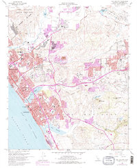
1968 Map of San Luis Rey
USGS Topo · Published 1978About this map
Mission San Luis Rey de Francia serves as a historic anchor for this coastal California landscape, surrounded by the growing mid-century settlements of Oceanside, Carlsbad, and Vista. The map documents a period of significant urban expansion, highlighted by purple tinting that illustrates the widening footprints of residential and commercial development near Buena Vista Lagoon and the San Luis Rey River. Educational and civic growth is evident through numerous institutions like MiraCosta College and San Luis Rey Academy, while the northern portion is dominated by the expansive Camp Pendleton Marine Corps Base.
Find a feature on this map
73 named features on this map. Tap any name to fly to it.
Don’t see what you’re looking for? This feature index may not catch every label — zoom into the map to look around manually.
Map Details
Editions of this 1968 San Luis Rey Map
3 editions found
Other maps of this area

1893 · Oceanside
USGS Topo · 1:62,500

1893 · Escondido
USGS Topo · 1:62,500

1898 · Oceanside
USGS Topo · 1:62,500

1901 · Escondido
USGS Topo · 1:62,500

1901 · Oceanside
USGS Topo · 1:62,500

1901 · San Luis Rey
USGS Topo · 1:125,000

1904 · Southern California Sheet No. 2
USGS Topo · 1:250,000

1941 · Margarita Peak
USGS Topo · 1:62,500

1942 · Margarita Peak
USGS Topo · 1:62,500

1942 · Temecula
USGS Topo · 1:62,500