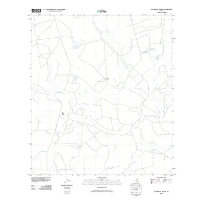
2010 Map of San Miguel Ranch
USGS Topo · Published 2010About this map
San Miguel Ranch serves as the central landmark for this Atascosa County landscape, where the hydrography reveals an intricate system of water management essential for South Texas ranching. The presence of several named impoundments, including T H Cattle Company Lake and Erwin Lake, underscores the importance of surface water collection in this semi-arid region. These reservoirs are fed by a network of seasonal drainages such as Lagunillas Creek, Macho Creek, and Lake Branch, all of which eventually contribute to the larger San Miguel Creek basin.
Find a feature on this map
20 named features on this map. Tap any name to fly to it.
Don’t see what you’re looking for? This feature index may not catch every label — zoom into the map to look around manually.
Map Details
Editions of this 2010 San Miguel Ranch Map
This is the sole edition of this map. No revisions or reprints were ever made.
Other maps of this area

1934 · Schattel
USGS Topo · 1:62,500

1953 · Crystal City
USGS Topo · 1:250,000

1955 · Crystal City
USGS Topo · 1:250,000

1956 · Jourdanton
USGS Topo · 1:62,500

1956 · Hindes
USGS Topo · 1:62,500

1956 · Franklin Settlement
USGS Topo · 1:62,500

1961 · Crystal City
USGS Topo · 1:250,000

1968 · Crystal City
USGS Topo · 1:250,000
1968 · Charlotte
USGS Topo · 1:24,000
1968 · Christine West
USGS Topo · 1:24,000