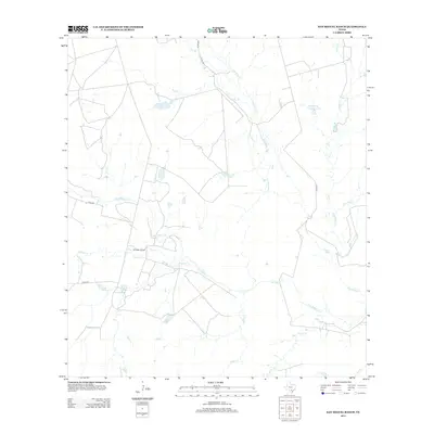
2013 Map of San Miguel Ranch
USGS Topo · Published 2013About this map
San Miguel Ranch sits at the heart of this South Texas landscape, defined by an intricate network of seasonal drainages and stock tanks in Atascosa County. The terrain is shaped by the winding course of San Miguel Cr, which is joined by numerous tributaries including Raccoon Cr and Indian Cr. This 2013 survey illustrates the ranching heritage of the region, featuring named water bodies such as Hindes Lake and the T-H Cattle Company Lake. Sparse development is connected by a grid of county roads, including Co RD 346 and Co RD 343, which navigate the land between Lagunillas Cr and Macho Cr. The map provides a detailed view of the local hydrography, essential for understanding the agricultural and land-use patterns of this rural Texas territory.
Find a feature on this map
17 named features on this map. Tap any name to fly to it.
Don’t see what you’re looking for? This feature index may not catch every label — zoom into the map to look around manually.
Map Details
Editions of this 2013 San Miguel Ranch Map
This is the sole edition of this map. No revisions or reprints were ever made.
Other maps of this area

1934 · Schattel
USGS Topo · 1:62,500

1953 · Crystal City
USGS Topo · 1:250,000

1955 · Crystal City
USGS Topo · 1:250,000

1956 · Jourdanton
USGS Topo · 1:62,500

1956 · Hindes
USGS Topo · 1:62,500

1956 · Franklin Settlement
USGS Topo · 1:62,500

1961 · Crystal City
USGS Topo · 1:250,000

1968 · Crystal City
USGS Topo · 1:250,000
1968 · Charlotte
USGS Topo · 1:24,000
1968 · Christine West
USGS Topo · 1:24,000