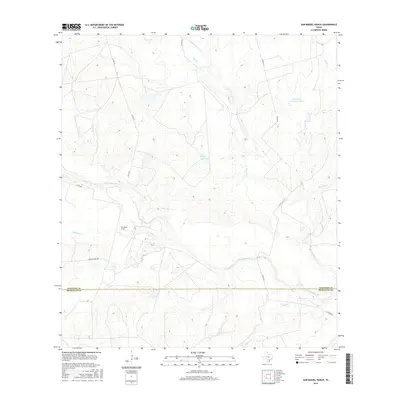
2016 Map of San Miguel Ranch
USGS Topo · Published 2016About this map
San Miguel Ranch sits at the heart of this South Texas landscape, where the seasonal hydrology of the brush country dictates the placement of roads and homesteads. The terrain is defined by a dense network of intermittent drainages, most notably San Miguel Cr, Lagunillas Cr, and Macho Cr, which converge as they flow toward the McMullen County line. Ranching operations are supported by numerous named tanks and reservoirs, including the T H Cattle Company Lake, Hindes Lake, and Erwin Lake. These water sources are critical features in a region where natural permanent water is scarce. The map details the rural infrastructure of the mid-2010s, tracing gravel routes like Hinsley Ranch Rd and Yeager Rd that connect isolated ranching outposts across the Atascosa and McMullen county line.
Find a feature on this map
20 named features on this map. Tap any name to fly to it.
Don’t see what you’re looking for? This feature index may not catch every label — zoom into the map to look around manually.
Map Details
Editions of this 2016 San Miguel Ranch Map
This is the sole edition of this map. No revisions or reprints were ever made.
Other maps of this area

1934 · Schattel
USGS Topo · 1:62,500

1953 · Crystal City
USGS Topo · 1:250,000

1955 · Crystal City
USGS Topo · 1:250,000

1956 · Jourdanton
USGS Topo · 1:62,500

1956 · Hindes
USGS Topo · 1:62,500

1956 · Franklin Settlement
USGS Topo · 1:62,500

1961 · Crystal City
USGS Topo · 1:250,000

1968 · Crystal City
USGS Topo · 1:250,000
1968 · Charlotte
USGS Topo · 1:24,000
1968 · Christine West
USGS Topo · 1:24,000