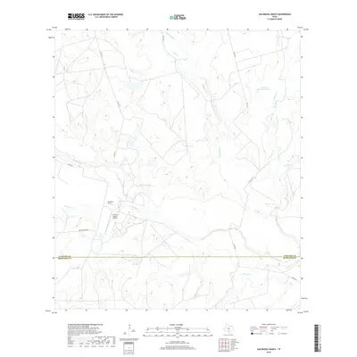
2019 Map of San Miguel Ranch
USGS Topo · Published 2019About this map
The San Miguel Ranch sits at the heart of this South Texas landscape, where the border between Atascosa and McMullen counties is defined by a straight survey line cutting through rolling drainage basins. This area is characterized by an extensive network of seasonal and perennial waterways that feed into San Miguel Cr, which snakes across the southern portion of the sheet. Ranching operations are central to the landscape, evidenced by the El Tesoro Ranch Airport and significant water management features like Hindes Lake and T H Cattle Company Lake. The road network, including Co RD 3455 and Hinsley Ranch Rd, provides access to these isolated holdings. Small private reservoirs such as Erwin Lake illustrate the critical importance of water storage for livestock in this semi-arid environment.
Find a feature on this map
21 named features on this map. Tap any name to fly to it.
Don’t see what you’re looking for? This feature index may not catch every label — zoom into the map to look around manually.
Map Details
Editions of this 2019 San Miguel Ranch Map
This is the sole edition of this map. No revisions or reprints were ever made.
Other maps of this area

1934 · Schattel
USGS Topo · 1:62,500

1953 · Crystal City
USGS Topo · 1:250,000

1955 · Crystal City
USGS Topo · 1:250,000

1956 · Jourdanton
USGS Topo · 1:62,500

1956 · Hindes
USGS Topo · 1:62,500

1956 · Franklin Settlement
USGS Topo · 1:62,500

1961 · Crystal City
USGS Topo · 1:250,000

1968 · Crystal City
USGS Topo · 1:250,000
1968 · Charlotte
USGS Topo · 1:24,000
1968 · Christine West
USGS Topo · 1:24,000