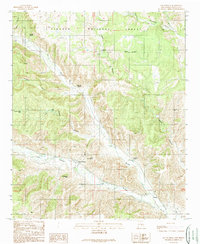
1989 Map of San Patricio
USGS Topo · Published 1989About this map
San Patricio and the Rio Bonito valley dominate this landscape in south-central New Mexico, where the confluence of several rivers creates a fertile corridor amidst the surrounding foothills. This area, largely comprised of the Lincoln National Forest, shows a settlement pattern deeply tied to water and family history. The influence of the Fritz family is visible through features like Emil Fritz Spring, Colonel Fritz Spring, and the Fritz Cemetery. Historical transit is represented by the Whiskey Trail, which winds through the rugged canyons. The geography is defined by prominent landmarks such as El Sentinel Peak and La Tetita Peak, while the union of the Rio Ruidoso and Rio Bonito forms the Rio Hondo near Hondo P O. This detailed survey preserves the ranching and agricultural layout of the valley as it existed before late-20th-century modernization.
Find a feature on this map
31 named features on this map. Tap any name to fly to it.
Don’t see what you’re looking for? This feature index may not catch every label — zoom into the map to look around manually.
Map Details
Editions of this 1989 San Patricio Map
This is the sole edition of this map. No revisions or reprints were ever made.
Other maps of this area

1935 · Capitan Mountains
USGS Topo · 1:48,000

1936 · Arabela
USGS Topo · 1:48,000

1940 · Capitan Mountains
USGS Topo · 1:62,500

1942 · Arabela
USGS Topo · 1:62,500

1955 · Roswell
USGS Topo · 1:250,000

1958 · Roswell
USGS Topo · 1:250,000

1961 · Lincoln
USGS Topo · 1:62,500

1961 · Tinnie
USGS Topo · 1:62,500

1962 · Roswell
USGS Topo · 1:250,000
1981 · Capitan Pass
USGS Topo · 1:24,000