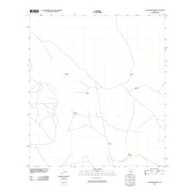
2010 Map of San Pedro Ranch
USGS Topo · Published 2010About this map
San Pedro Ranch anchors this portion of Kenedy County, illustrating the expansive cattle-ranching operations that define this region of South Texas. The landscape is marked by a network of ranch roads and a critical infrastructure of water sources. Named windmills are dispersed throughout the territory, serving as vital landmarks for navigation and land management. These include Piedra Trap Windmill, Rodeo Windmill, and Huisache Windmill, names that reflect the local vegetation and ranching activities. Further east, San Antonio Windmill and San Francisco Windmill provide essential water in this arid environment, where topographic relief is minimal and the distance between established outposts is significant.
Find a feature on this map
7 named features on this map. Tap any name to fly to it.
Don’t see what you’re looking for? This feature index may not catch every label — zoom into the map to look around manually.
Map Details
Editions of this 2010 San Pedro Ranch Map
This is the sole edition of this map. No revisions or reprints were ever made.
Other maps of this area

1923 · Armstrong
USGS Topo · 1:62,500

1923 · Saltillo Ranch
USGS Topo · 1:62,500

1928 · Sarita
USGS Topo · 1:125,000

1950 · Corpus Christi
USGS Topo · 1:250,000

1952 · Sarita 4 SE
USGS Topo · 1:24,000

1953 · Brownsville
USGS Topo · 1:250,000

1954 · La Parra Ranch SW
USGS Topo · 1:24,000

1954 · Sarita
USGS Topo · 1:62,500
1955 · La Parra Ranch
USGS Topo · 1:62,500

1956 · Corpus Christi
USGS Topo · 1:250,000