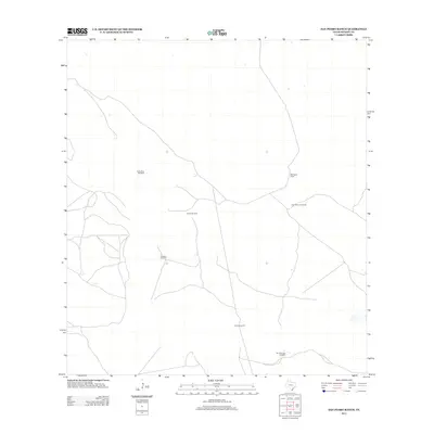
2013 Map of San Pedro Ranch
USGS Topo · Published 2013About this map
San Pedro Ranch sits at the heart of this coastal South Texas landscape, where the vast cattle country of Kenedy County depends on a network of water sources. The map documents an area defined by functional landmarks, primarily several named windmills that provide vital water in this arid environment. These features, including San Antonio Windmill, San Francisco Windmill, and Piedra Trap Windmill, serve as the primary navigational and operational hubs for ranching activities. The sparse distribution of Rodeo Windmill, Huisache Windmill, and Emes Windmill illustrates the immense scale of individual land holdings and the specific infrastructure required to maintain livestock in this part of the state. The layout of local roads and paths reflects a landscape focused on ranch management and transit through open range land.
Find a feature on this map
7 named features on this map. Tap any name to fly to it.
Don’t see what you’re looking for? This feature index may not catch every label — zoom into the map to look around manually.
Map Details
Editions of this 2013 San Pedro Ranch Map
This is the sole edition of this map. No revisions or reprints were ever made.
Other maps of this area

1923 · Armstrong
USGS Topo · 1:62,500

1923 · Saltillo Ranch
USGS Topo · 1:62,500

1928 · Sarita
USGS Topo · 1:125,000

1950 · Corpus Christi
USGS Topo · 1:250,000

1952 · Sarita 4 SE
USGS Topo · 1:24,000

1953 · Brownsville
USGS Topo · 1:250,000

1954 · La Parra Ranch SW
USGS Topo · 1:24,000

1954 · Sarita
USGS Topo · 1:62,500
1955 · La Parra Ranch
USGS Topo · 1:62,500

1956 · Corpus Christi
USGS Topo · 1:250,000