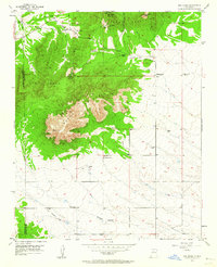
1954 Map of San Pedro
USGS Topo · Published 1964About this map
South Mountain and the San Pedro Mountains dominate this central New Mexico landscape, where the intersections of Santa Fe, Sandoval, and Bernalillo counties meet. The high-altitude terrain is marked by a history of extraction and transit, visible in the Mine Tailings near San Pedro and the Old Railroad Grade traversing the southwest through Homes Valley. Family holdings and small settlements are scattered across the slopes and lower basins, including the Palo Amarillo Ranch, Simmons Ranch, and Stewart Ranch. Local genealogy is anchored by the San Pedro Cemetery and Mountain View Cemetery on the eastern periphery. The drainage patterns of Cañon del Agua and San Lazarus Gulch dictate the placement of ranching outposts like Ranchito and the isolated Horton Place in a region where water sources such as Cañon del Agua Springs were vital to survival.
Find a feature on this map
24 named features on this map. Tap any name to fly to it.
Don’t see what you’re looking for? This feature index may not catch every label — zoom into the map to look around manually.
Map Details
Editions of this 1954 San Pedro Map
3 editions found
Other maps of this area

1892 · San Pedro
USGS Topo · 1:125,000

1954 · Sandia Park
USGS Topo · 1:24,000

1954 · San Pedro
USGS Topo · 1:24,000

1954 · Sedillo
USGS Topo · 1:24,000

1954 · Hagan
USGS Topo · 1:24,000

1954 · Edgewood
USGS Topo · 1:24,000

1954 · San Felipe Pueblo
USGS Topo · 1:62,500

1956 · Edgewood
USGS Topo · 1:62,500

1958 · Albuquerque
USGS Topo · 1:250,000

1961 · Madrid
USGS Topo · 1:62,500