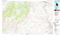
1986 Map of San Rafael Desert
USGS Topo · Published 1987About this map
The San Rafael Swell and the surrounding San Rafael Country define this mid-1980s landscape, where geological uplift meets the winding path of the Green River. The topography is dominated by the dramatic San Rafael Reef, a sawtooth ridge of sandstone that separates the high plateau from the lower San Rafael Desert. This era shows a unique overlap of recreation and high-technology defense; while the Goblin Valley State Reserve protects whimsical rock formations, the northeastern corner is occupied by the Utah Launch Complex and its associated Missile Range. Transportation is anchored by the Denver and Rio Grande Western railroad and Interstate 70, which cut through the northern portion near the settlements of Green River and Elgin. Resource extraction remains evident through scattered sites like the Copper Globe Mine and Lucky Strike Mine, illustrating the persistent effort to find value in this arid environment.
Find a feature on this map
88 named features on this map. Tap any name to fly to it.
Don’t see what you’re looking for? This feature index may not catch every label — zoom into the map to look around manually.
Map Details
Editions of this 1986 San Rafael Desert Map
2 editions found
Other maps of this area

1885 · San Rafael
USGS Topo · 1:250,000

1885 · Manti
USGS Topo · 1:250,000

1885 · East Tavaputs
USGS Topo · 1:250,000

1885 · La Sal
USGS Topo · 1:250,000

1885 · Fish Lake
USGS Topo · 1:250,000

1886 · Price River
USGS Topo · 1:250,000

1895 · Manti
USGS Topo · 1:250,000

1896 · Price River
USGS Topo · 1:250,000

1896 · Fish Lake
USGS Topo · 1:250,000

1923 · Castle Dale
USGS Topo · 1:62,500