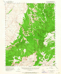
1952 Map of San Rafael Knob
USGS Topo · Published 1964About this map
The San Rafael Swell dominates this 1952 topographic study, revealing a landscape of high desert mesas and deep erosion in the heart of Sinbad Country. At the center of the sheet, San Rafael Knob stands as the highest point, surrounded by distinct geological formations such as The Blocks, Chimney Rock, and the curiously named Joe and His Dog. These landmarks served as vital navigational aids for the early ranchers and miners who traversed this region.
Find a feature on this map
61 named features on this map. Tap any name to fly to it.
Don’t see what you’re looking for? This feature index may not catch every label — zoom into the map to look around manually.
Map Details
Editions of this 1952 San Rafael Knob Map
2 editions found

Other maps of this area

1885 · San Rafael
USGS Topo · 1:250,000

1885 · Manti
USGS Topo · 1:250,000

1885 · Fish Lake
USGS Topo · 1:250,000

1886 · Price River
USGS Topo · 1:250,000

1895 · Manti
USGS Topo · 1:250,000

1896 · Price River
USGS Topo · 1:250,000

1896 · Fish Lake
USGS Topo · 1:250,000

1923 · Castle Dale
USGS Topo · 1:62,500

1925 · Castle Dale
USGS Topo · 1:62,500

1952 · Wild Horse
USGS Topo · 1:62,500