1950 Map of San Sebastian NO
USGS Topo · Published 1950About this map
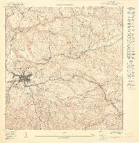
San Sebastián serves as the focal point of this mid-century survey, showing the urban street grid and surrounding agricultural barrios before the era of major highway expansion. The landscape is defined by the winding course of the Río Culebrinas and Río Guatemala, with the Acueducto de San Sebastián marking the critical water infrastructure of the period. Local landmarks like the Iglesia Presbiteriana appear in the outlying Piedras Blancas barrio.
Find a feature on this map
25 named features on this map. Tap any name to fly to it.
Don’t see what you’re looking for? This feature index may not catch every label — zoom into the map to look around manually.
Map Details
Editions of this 1950 San Sebastian NO Map
This is the sole edition of this map. No revisions or reprints were ever made.
Other maps of this area

1937 · Moca
USGS Topo · 1:20,000

1938 · Alto Sano
USGS Topo · 1:20,000

1938 · San Sebastian
USGS Topo · 1:20,000

1938 · Quebradillas
USGS Topo · 1:20,000

1941 · Moca
USGS Topo · 1:30,000

1941 · San Sebastian
USGS Topo · 1:30,000

1942 · Moca
USGS Topo · 1:30,000

1942 · Central La Plata
USGS Topo · 1:30,000

1946 · Ciales
USGS Topo · 1:30,000
1950 · Moca SE
USGS Topo · 1:10,000
Featured Places
- San Sebastián, San Sebastián
- Sector Carmelo Méndez, San Sebastián
- Mansiones de Culebrina, San Sebastián
- Sector Moncho López, San Sebastián
- Sector El Rincón, San Sebastián