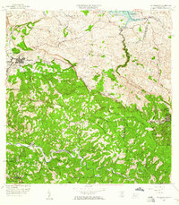
1958 Map of San Sebastian
USGS Topo · Published 1960About this map
San Sebastián serves as the focal point of this 1958 revision, situated at the intersection of critical island routes and surrounded by a landscape defined by its agricultural heritage. The presence of numerous named haciendas, including Hacienda San Pedro, Hacienda Buena Vista, and Hacienda Espino, points to a persistent land-tenure system rooted in the coffee and sugar economies of the interior. To the northeast, the Lago de Guajataca reservoir and the adjacent Campamento Guajataca illustrate the integration of water resource management and recreational infrastructure during this era of Puerto Rican development.
Find a feature on this map
88 named features on this map. Tap any name to fly to it.
Don’t see what you’re looking for? This feature index may not catch every label — zoom into the map to look around manually.
Map Details
Editions of this 1958 San Sebastian Map
3 editions found
Other maps of this area

1937 · Moca
USGS Topo · 1:20,000

1938 · Alto Sano
USGS Topo · 1:20,000

1938 · Camuy
USGS Topo · 1:20,000

1938 · San Sebastian
USGS Topo · 1:20,000

1938 · Quebradillas
USGS Topo · 1:20,000

1941 · Moca
USGS Topo · 1:30,000

1941 · San Sebastian
USGS Topo · 1:30,000

1941 · Rosario
USGS Topo · 1:30,000

1942 · Moca
USGS Topo · 1:30,000

1942 · Central La Plata
USGS Topo · 1:30,000