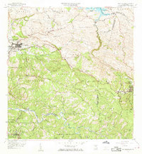
1958 Map of San Sebastian
USGS Topo · Published 1968About this map
San Sebastian serves as the focal point of this 1958 survey, showing the town's early footprint before decades of modern expansion. The landscape is defined by the steep valleys of the Rio Guajataca and the winding course of the Rio Grande de Anasco, where agriculture and landownership patterns are preserved through named estates. The map identifies several traditional agricultural holdings, including Hacienda San Pedro, Hacienda Buena Vista, and Hacienda Esperanza, offering a look at the rural economy of the mid-20th century.
Find a feature on this map
83 named features on this map. Tap any name to fly to it.
Don’t see what you’re looking for? This feature index may not catch every label — zoom into the map to look around manually.
Map Details
Editions of this 1958 San Sebastian Map
3 editions found
Other maps of this area

1937 · Moca
USGS Topo · 1:20,000

1938 · Alto Sano
USGS Topo · 1:20,000

1938 · Camuy
USGS Topo · 1:20,000

1938 · San Sebastian
USGS Topo · 1:20,000

1938 · Quebradillas
USGS Topo · 1:20,000

1941 · Moca
USGS Topo · 1:30,000

1941 · San Sebastian
USGS Topo · 1:30,000

1941 · Rosario
USGS Topo · 1:30,000

1942 · Moca
USGS Topo · 1:30,000

1942 · Central La Plata
USGS Topo · 1:30,000