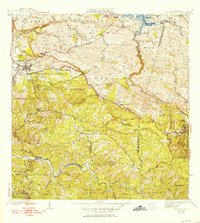
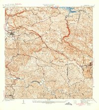
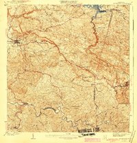
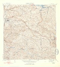
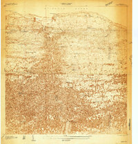
1941 Map of San Sebastian
USGS Topo · Published 1953About this map
San Sebastian and Lares anchor this mid-century view of the interior highlands, where the rugged topography of Puerto Rico's northwest karst region is defined by deep river valleys and limestone ridges. The northern reaches are dominated by the Lago Guajataca reservoir and the winding Rio Guajataca, while the southern landscape drops into the drainage basin of the Rio Anasco. This era of development is visible in the network of primary and secondary roads connecting barrios like Piedras Blancas, Hoya Mala, and Guajataca. Cultural landmarks include the Iglesia Santa Ana, the Iglesia Presbiteriana, and the Acueducto de San Sebastian, reflecting the growing infrastructure and community life of the 1930s and 40s. The map also delineates the complex municipal boundaries where San Sebastian meets Lares and Las Marias.
Find a feature on this map
64 named features on this map. Tap any name to fly to it.
Don’t see what you’re looking for? This feature index may not catch every label — zoom into the map to look around manually.
Map Details
Editions of this 1941 San Sebastian Map
5 editions found
Other maps of this area

1937 · Moca
USGS Topo · 1:20,000

1938 · Alto Sano
USGS Topo · 1:20,000
1938 · Camuy
USGS Topo · 1:20,000

1938 · San Sebastian
USGS Topo · 1:20,000

1938 · Quebradillas
USGS Topo · 1:20,000

1941 · Moca
USGS Topo · 1:30,000

1941 · San Sebastian
USGS Topo · 1:30,000

1941 · Rosario
USGS Topo · 1:30,000

1942 · Moca
USGS Topo · 1:30,000

1942 · Central La Plata
USGS Topo · 1:30,000
Featured Places
- San Sebastián, San Sebastián
- Lares, Lares
- Las Marías, Las Marías
- Sector Quinto Ríos, San Sebastián
- Sector Isidro Román, Lares