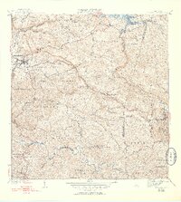
1941 Map of San Sebastian
USGS Topo · Published 1953About this map
San Sebastian serves as the focal point for this survey of western Puerto Rico, where the dense network of barrios and watercourses reveals a landscape defined by its agricultural and municipal boundaries. The map documents numerous traditional districts including Piedras Blancas, Calabazas, and Guayataca, while the northern edge is dominated by the waters of Lago Guajataca. In the town center, community life is anchored by landmarks like the Iglesia Santa Ana and the Iglesia Presbiteriana, alongside vital infrastructure such as the Acueducto de San Sebastian. To the south, the terrain descends toward the Rio Grande de Anasco, intersected by countless quebradas such as Quebrada Culebrinas and Quebrada Lajas. This mid-century record provides a clear view of the rural settlement patterns before modern expansion altered the original barrio lines.
Find a feature on this map
76 named features on this map. Tap any name to fly to it.
Don’t see what you’re looking for? This feature index may not catch every label — zoom into the map to look around manually.
Map Details
Editions of this 1941 San Sebastian Map
5 editions found
Other maps of this area

1937 · Moca
USGS Topo · 1:20,000

1938 · Alto Sano
USGS Topo · 1:20,000

1938 · Camuy
USGS Topo · 1:20,000

1938 · San Sebastian
USGS Topo · 1:20,000

1938 · Quebradillas
USGS Topo · 1:20,000

1941 · Moca
USGS Topo · 1:30,000

1941 · San Sebastian
USGS Topo · 1:30,000

1941 · Rosario
USGS Topo · 1:30,000

1942 · Moca
USGS Topo · 1:30,000

1942 · Central La Plata
USGS Topo · 1:30,000