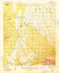
1948 Map of San Vicente
USGS Topo · Published 1948About this map
The Papago Indian Reservation dominates this 1938 survey of the desert landscape west of Tucson. Small settlements and ranching outposts such as Schuchk, San Vicente, and Havana Nakya are scattered across the valley floor, connected by primitive desert tracks and the developing Ajo - Tucson Highway. The topography is defined by sharp elevation shifts, from the low-lying Coyote Field to the prominent Coyote Mountains and North Comobabi Mountains.
Find a feature on this map
21 named features on this map. Tap any name to fly to it.
Don’t see what you’re looking for? This feature index may not catch every label — zoom into the map to look around manually.
Map Details
Editions of this 1948 San Vicente Map
2 editions found

Other maps of this area

1920 · Arivaca
USGS Topo · 1:125,000

1934 · Tucson Mountains
USGS Topo · 1:125,000

1934 · Silver Bell
USGS Topo · 1:125,000

1937 · Comobabi
USGS Topo · 1:48,000

1938 · San Vicente
USGS Topo · 1:62,500

1940 · Palo Alto Ranch
USGS Topo · 1:62,500

1941 · San Vicente
USGS Topo · 1:62,500

1941 · Cocoraque Butte
USGS Topo · 1:62,500

1941 · Baboquivari Peak
USGS Topo · 1:62,500

1941 · Sells
USGS Topo · 1:62,500
Featured Places
- Schuk Toak District, AZ
- Haivana Nakya, Schuk Toak District
- Pan Tak, Schuk Toak District
- Schuchk, Schuk Toak District
- San Vicente, Schuk Toak District