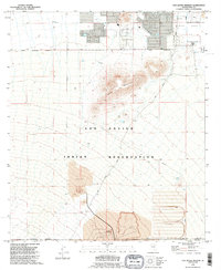
1992 Map of San Xavier Mission
USGS Topo · Published 1995About this map
San Xavier del Bac Mission stands as a prominent cultural landmark in the northeastern portion of this 1990s survey, situated within the Santa Cruz Valley. The landscape is defined by the extensive San Xavier Indian Reservation, which encompasses a mix of traditional land use and significant industrial activity. Major terrain features like Black Mountain and Twin Buttes dominate the central topography, while the southern reaches show heavy modification from resource extraction, characterized by a large Quarry, a Mine Dump, and extensive Tailings piles. Transportation through the reservation is facilitated by Mission Road and the Twin Buttes Road, alongside the industrial utility of the Pima Spur railroad line. Traces of historical land tenure appear in the Rancho de Martinez boundary, while modern utility is represented by a Powder Magazine and a network of pipelines and wells.
Find a feature on this map
27 named features on this map. Tap any name to fly to it.
Don’t see what you’re looking for? This feature index may not catch every label — zoom into the map to look around manually.
Map Details
Editions of this 1992 San Xavier Mission Map
This is the sole edition of this map. No revisions or reprints were ever made.
Other maps of this area

1904 · Patagonia
USGS Topo · 1:125,000

1904 · Tucson
USGS Topo · 1:125,000

1905 · Patagonia
USGS Topo · 1:125,000

1905 · Tucson
USGS Topo · 1:125,000

1920 · Arivaca
USGS Topo · 1:125,000

1925 · Samaniego Peak
USGS Topo · 1:62,500

1925 · San Xavier
USGS Topo · 1:62,500

1926 · Helvetia
USGS Topo · 1:62,500

1934 · Tucson Mountains
USGS Topo · 1:125,000

1939 · Twin Buttes
USGS Topo · 1:62,500