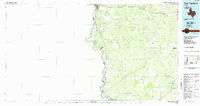
1985 Map of San Ygnacio
USGS Topo · Published 1985About this map
The Rio Grande carves the international boundary between Texas and Mexico in this mid-1980s survey, marking the western edge of Zapata and Webb counties. The riverfront is characterized by a dense network of intermittent arroyos, such as Arroyo Dolores and Arroyo San Francisco, which drain the dry ranchlands toward the river valley. In the north, the urban reach of Laredo contrasts with the small, historic settlements of San Ygnacio and Ramireño downstream.
Find a feature on this map
50 named features on this map. Tap any name to fly to it.
Don’t see what you’re looking for? This feature index may not catch every label — zoom into the map to look around manually.
Map Details
Editions of this 1985 San Ygnacio Map
3 editions found
Other maps of this area

1933 · Becerra Creek
USGS Topo · 1:62,500

1937 · Aguilete Creek
USGS Topo · 1:62,500

1938 · Cuevitas
USGS Topo · 1:62,500

1939 · Bruni
USGS Topo · 1:62,500

1939 · Randado
USGS Topo · 1:62,500

1940 · Aguilares
USGS Topo · 1:62,500

1940 · Randado
USGS Topo · 1:62,500

1940 · Mogotes Hill
USGS Topo · 1:62,500

1942 · San Ygnacio
USGS Topo · 1:62,500

1949 · Mc Allen
USGS Topo · 1:250,000