
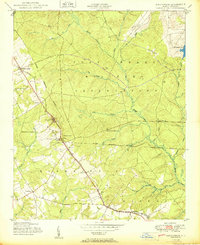
1950 Map of Sanatorium
USGS Topo · Published 1950About this map
The State Tuberculosis Sanatorium serves as the central landmark of this mid-century topographic study, positioned alongside the Aberdeen and Rockfish railroad corridor. This transportation spine connects small settlements like Montrose, Ashmont, and Ashley Heights across a landscape defined by the drainage of Rockfish Creek and its many tributaries. The area is characterized by a mix of institutional grounds and rural industry, evidenced by the Cabin Branch Mill Pond and various sidings along the rail line, such as Pooles Siding. Much of the eastern and northern portions are occupied by the Fort Bragg Military Reservation, establishing a clear boundary between the developing civilian communities and the expansive federal land. Local spiritual and communal life is anchored by sites like Sandy Grove Ch and several small cemeteries scattered throughout the wooded terrain.
Find a feature on this map
32 named features on this map. Tap any name to fly to it.
Don’t see what you’re looking for? This feature index may not catch every label — zoom into the map to look around manually.
Map Details
Editions of this 1950 Sanatorium Map
2 editions found
Other maps of this area

1948 · Southern Pines
USGS Topo · 1:62,500

1948 · Clifdale
USGS Topo · 1:62,500

1948 · Pinebluff
USGS Topo · 1:24,000

1948 · Nicholson Creek
USGS Topo · 1:24,000

1948 · Mc Cain
USGS Topo · 1:24,000

1949 · Wagram
USGS Topo · 1:24,000

1949 · Silver Hill
USGS Topo · 1:24,000

1949 · Laurinburg
USGS Topo · 1:62,500

1950 · Lobelia
USGS Topo · 1:24,000

1950 · Pine Bluff
USGS Topo · 1:24,000