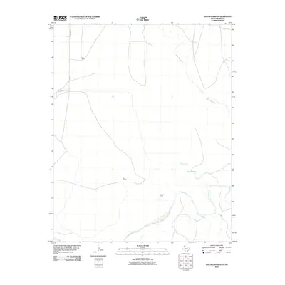
2010 Map of Sanchez Springs
USGS Topo · Published 2010About this map
The Canadian River meanders across the southern portion of this high plains landscape, defining the topography of Quay County as it appeared in the early 21st century. This arid terrain is marked by essential water sources and seasonal drainage features, most notably the Nara Visa Arroyo and the namesake Sanchez Springs. The settlement pattern is sparse, reflecting the ranching heritage and resource-based land use of eastern New Mexico. Scattered landmarks such as Dean Ranch and Coggins Camp serve as focal points for local history and genealogy research, while the presence of the New Windmill and Sanchez Tank underscores the importance of water management in this environment. Modern infrastructure is represented by a grid of rural routes including Quay Road F and Quay Road K, providing access to these remote ranching outposts.
Find a feature on this map
10 named features on this map. Tap any name to fly to it.
Don’t see what you’re looking for? This feature index may not catch every label — zoom into the map to look around manually.
Map Details
Editions of this 2010 Sanchez Springs Map
This is the sole edition of this map. No revisions or reprints were ever made.
Other maps of this area

1954 · Tucumcari
USGS Topo · 1:250,000

1958 · Tucumcari
USGS Topo · 1:250,000

1966 · Signal Spring
USGS Topo · 1:24,000

1966 · Trujillo Camp
USGS Topo · 1:24,000

1968 · Blue Hole
USGS Topo · 1:24,000

1968 · Cammak Camp
USGS Topo · 1:24,000

1968 · Sanchez Springs
USGS Topo · 1:24,000
1968 · Martin Draw
USGS Topo · 1:24,000

1971 · Obar
USGS Topo · 1:24,000

1971 · Nara Visa
USGS Topo · 1:24,000