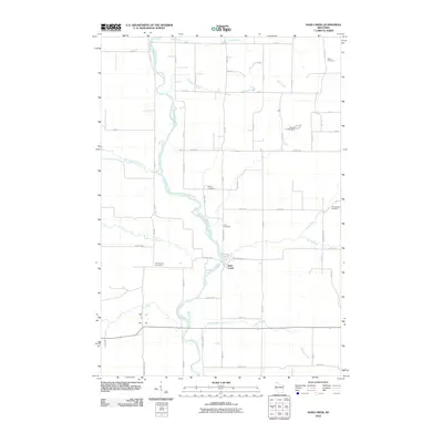
2010 Map of Sand Creek
USGS Topo · Published 2010About this map
The Red Cedar River defines the central topography of this region, winding past the village of Sand Creek as it flows south through Dunn County. This landscape is characterized by a grid-like network of rural roads that connect family farmsteads and historic community hubs. The area is dotted with several ancestral burial grounds, including the Dovre Cemetery in the north and the Springbrook Cemetery to the east, which speak to the long-standing settlement of the surrounding townships. Water management and hydrology are central to the area's development, evidenced by the Toycen G 5925 Dam and the numerous tributaries like Cruikshank Creek and Tiller Creek that feed into the main river channel. These waterways created a natural corridor for early transportation and industry in the northern Wisconsin interior.
Find a feature on this map
58 named features on this map. Tap any name to fly to it.
Don’t see what you’re looking for? This feature index may not catch every label — zoom into the map to look around manually.
Map Details
Editions of this 2010 Sand Creek Map
This is the sole edition of this map. No revisions or reprints were ever made.
Other maps of this area

1949 · New Auburn
USGS Topo · 1:62,500

1949 · Ridgeland
USGS Topo · 1:62,500

1951 · Ridgeland
USGS Topo · 1:62,500

1951 · New Auburn
USGS Topo · 1:62,500

1951 · Chetek
USGS Topo · 1:62,500

1951 · Barron
USGS Topo · 1:62,500

1953 · Rice Lake
USGS Topo · 1:250,000

1959 · Rice Lake
USGS Topo · 1:250,000
1975 · Colfax North
USGS Topo · 1:24,000
1975 · New Auburn
USGS Topo · 1:24,000