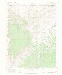
1967 Map of Sand Creek Pass
USGS Topo · Published 1971About this map
Roosevelt National Forest spans the high-elevation terrain where Larimer County, Colorado, meets Albany County, Wyoming. This late 1960s survey documents a landscape defined by significant drainage systems and prominent landmarks like the massive Bull Mountain and the sprawling Boulder Ridge. Movement through this high-country environment is facilitated by a network of Jeep Trails and Pack Trails, emphasizing the area's use for remote access and forestry management rather than permanent settlement. The hydrology is particularly well-detailed, showing the headwaters of Shell Creek, Sand Creek, and Dry Creek. Of specific interest to those tracking historic water sources are several named locations like Jimmy Spring and Jimmy Creek Spring, which provided reliable water at the Sand Creek Pass crossing during an era of expanding back-country recreation and land management.
Find a feature on this map
21 named features on this map. Tap any name to fly to it.
Don’t see what you’re looking for? This feature index may not catch every label — zoom into the map to look around manually.
Map Details
Editions of this 1967 Sand Creek Pass Map
4 editions found
Other maps of this area

1895 · Laramie
USGS Topo · 1:125,000

1902 · Laramie
USGS Topo · 1:125,000

1905 · Laramie
USGS Topo · 1:125,000

1906 · Laramie
USGS Topo · 1:125,000

1908 · Laramie
USGS Topo · 1:125,000

1916 · Home
USGS Topo · 1:125,000

1920 · Home
USGS Topo · 1:125,000

1954 · Cheyenne
USGS Topo · 1:250,000

1954 · Greeley
USGS Topo · 1:250,000

1957 · Greeley
USGS Topo · 1:250,000