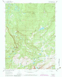
1961 Map of Sand Lake
USGS Topo · Published 1984About this map
Medicine Bow National Forest dominates this high-altitude landscape, where the Snowy Range rises in the south. The area is defined by its extensive alpine hydrology, including the headwaters of the Medicine Bow River and its East Fork, alongside dozens of named glacial lakes such as Sand Lake, Quealy Lake, and Black Spotted Lake. The terrain transitions from the open stretches of Stillwater Park and Johnson Park to prominent elevations like Lookout Mountain and Windy Hill. This survey highlights the region's recreational and navigational infrastructure, showing the Sheep Lake Trail and North Gap Lake Trail as they cross the boundary between Carbon and Albany counties. The map provides an essential look at this wilderness area before late 20th-century developments, preserving the original backcountry trail system and early forest management markers like the Bow River Overlook.
Find a feature on this map
42 named features on this map. Tap any name to fly to it.
Don’t see what you’re looking for? This feature index may not catch every label — zoom into the map to look around manually.
Map Details
Editions of this 1961 Sand Lake Map
3 editions found
Other maps of this area

1906 · Medicine Bow
USGS Topo · 1:125,000

1908 · Medicine Bow
USGS Topo · 1:125,000

1954 · Rawlins
USGS Topo · 1:250,000

1955 · Elk Mountain SW
USGS Topo · 1:24,000

1958 · Rawlins
USGS Topo · 1:250,000

1958 · White Rock Canyon
USGS Topo · 1:24,000

1958 · Arlington
USGS Topo · 1:24,000

1961 · Sand Lake
USGS Topo · 1:24,000

1961 · Medicine Bow Peak
USGS Topo · 1:24,000
1961 · Phantom Lake
USGS Topo · 1:24,000