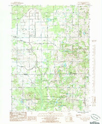
1985 Map of Sand Lake SW
USGS Topo · Published 1985About this map
The Rogue River winds through this West Michigan landscape, anchoring the Rogue River State Game Area south of the Newaygo and Kent county line. This mid-1980s landscape is characterized by a high density of small kettle lakes, including Ransom Lake, Frey Lake, and Butler Lake, which dot the townships of Grant, Ensley, Tyrone, and Solon. The area maintains a rural, community-focused character, evidenced by institutions like the Grant Christian Sch and the Lady of Guadalupe Mission. Aviation and industry leave their marks via the Bolthouse Landing Strip and scattered Gravel Pits, while the tiny settlement of Walter sits at the intersection of Twenty Mile Road and the river, reflecting the region's historical reliance on these crossroads for local commerce and transport.
Find a feature on this map
40 named features on this map. Tap any name to fly to it.
Don’t see what you’re looking for? This feature index may not catch every label — zoom into the map to look around manually.
Map Details
Editions of this 1985 Sand Lake SW Map
This is the sole edition of this map. No revisions or reprints were ever made.
Other maps of this area

1918 · Cedar Springs
USGS Topo · 1:62,500

1943 · Cedar Springs
USGS Topo · 1:62,500

1945 · Ravenna
USGS Topo · 1:62,500

1954 · Midland
USGS Topo · 1:250,000

1958 · Midland
USGS Topo · 1:250,000

1958 · Sand Lake
USGS Topo · 1:62,500

1958 · Fremont
USGS Topo · 1:62,500

1959 · Midland
USGS Topo · 1:250,000

1966 · Midland
USGS Topo · 1:250,000

1967 · Sparta
USGS Topo · 1:24,000