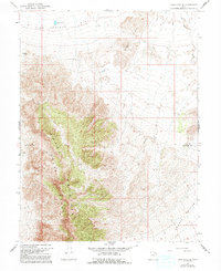
1967 Map of Sand Pass SE
USGS Topo · Published 1992About this map
Swasey House Range dominates the western half of this interior Utah landscape, rising sharply from the surrounding basins. This 1967 survey captures a remote expanse of the Great Basin where life and movement are dictated by the few reliable water sources and clearings. Artificial water storage, such as Swasey Point Res and Table Knoll Res, supports livestock or wildlife in an otherwise arid environment. Along the eastern edge of the range, a lone Landing Strip provides a critical connection to the outside world, while the vast Fish Springs Flat and Swasey Bottom stretch toward the horizon. The map also delineates the boundary between Juab Co and Millard Co, showing how political lines bisect the desert terrain regardless of the physical geography defined by landmarks like Table Knoll.
Find a feature on this map
9 named features on this map. Tap any name to fly to it.
Don’t see what you’re looking for? This feature index may not catch every label — zoom into the map to look around manually.
Map Details
Editions of this 1967 Sand Pass SE Map
2 editions found
Other maps of this area

1908 · Fish Springs
USGS Topo · 1:250,000

1910 · Fish Springs
USGS Topo · 1:250,000

1953 · Topaz Mtn
USGS Topo · 1:62,500

1953 · Delta
USGS Topo · 1:250,000

1958 · Delta
USGS Topo · 1:250,000

1962 · Delta
USGS Topo · 1:250,000

1967 · Sand Pass
USGS Topo · 1:24,000

1967 · Sand Pass NW
USGS Topo · 1:24,000

1967 · Sand Pass SE
USGS Topo · 1:24,000
1967 · Sand Pass NE
USGS Topo · 1:24,000