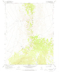
1968 Map of Sand Spring
USGS Topo · Published 1978About this map
Big Sand Springs Valley and the high elevations of the Pancake Range dominate this late-1960s survey of Nye County. The landscape is defined by its critical water sources, which were essential for survival and transit in this arid basin-and-range environment. Vital points such as Sand Spring, which includes a nearby water tank, Martilletti Spring, and Portuguese Spring appear along the western slopes of the mountains. These springs often dictated the paths of travel across the terrain, as evidenced by the network of jeep trails connecting the valleys. To the south, Portuguese Mountain stands as a prominent landmark above Ike Spring Wash, while the eastern portion of the map transitions into the Duckwater Valley. This map provides a clear record of the area's geography before later environmental or land-use changes, documenting the exact placement of remote water features used by ranchers and desert travelers.
Find a feature on this map
11 named features on this map. Tap any name to fly to it.
Don’t see what you’re looking for? This feature index may not catch every label — zoom into the map to look around manually.
Map Details
Editions of this 1968 Sand Spring Map
2 editions found
Other maps of this area

1956 · Lund
USGS Topo · 1:250,000

1960 · Lund
USGS Topo · 1:250,000

1964 · Blue Eagle Springs
USGS Topo · 1:62,500

1964 · Duckwater
USGS Topo · 1:62,500

1968 · Portuguese Mtn
USGS Topo · 1:62,500

1968 · Brown Summit
USGS Topo · 1:24,000
1968 · Brown Summit NW
USGS Topo · 1:24,000
1968 · Brown Summit SW
USGS Topo · 1:24,000
1968 · Sand Spring
USGS Topo · 1:24,000

1968 · Portuguese Mtn
USGS Topo · 1:24,000