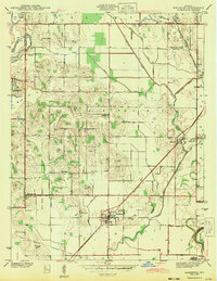
1943 Map of Sandborn
USGS Topo · Published 1943About this map
The town of Sandborn serves as a focal point in this southern Indiana landscape, situated at the intersection of the Pennsylvania railroad and several regional roads during the early 1940s. The map illustrates a transition from the structured street grids of Sandborn and Marco to the surrounding lowlands defined by Cane Green Bottom and the White River. An extensive network of drainage infrastructure, including Brewer Ditch and Slash Ditch, reveals the effort required to manage the area's hydrology for agriculture and industry. To the north and west, the terrain is marked by Strip Mine operations near Pleasantville and Sponsler, highlighting the importance of coal extraction to the local economy. Genealogists will find a wealth of local landmarks, from small country houses of worship like Burris Chapel and Stafford Ch to family and community burial grounds including Sandborn Cem and Begeman Cem.
Find a feature on this map
37 named features on this map. Tap any name to fly to it.
Don’t see what you’re looking for? This feature index may not catch every label — zoom into the map to look around manually.
Map Details
Editions of this 1943 Sandborn Map
2 editions found
Other maps of this area

1938 · Switz City
USGS Topo · 1:24,000

1940 · Linton
USGS Topo · 1:24,000

1943 · Lyons
USGS Topo · 1:24,000

1943 · Sandborn
USGS Topo · 1:24,000

1943 · Bicknell
USGS Topo · 1:24,000

1943 · Plainville
USGS Topo · 1:24,000

1943 · Dugger
USGS Topo · 1:24,000

1943 · Epsom
USGS Topo · 1:24,000

1944 · Bucktown
USGS Topo · 1:24,000

1947 · Switz City
USGS Topo · 1:24,000