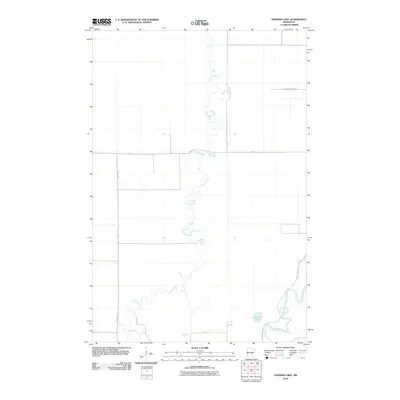
2010 Map of Sanders Lake
USGS Topo · Published 2010About this map
The winding Willow River defines the landscape of this Aitkin County region, snake-like as it meanders through low-lying terrain to its confluence with the Mississippi River in the southeast corner. This 2010 survey illustrates a sparsely populated area where the natural water systems dictate the road network and land use. The presence of the Savanna State Frst in the northeast indicates a protected wilderness character, while the small body of Sanders Lake sits near the river junction. A rigid grid of rural roads, including Nature Ave, 590th St, and 270th Ave, cuts across the wetlands, showing how modern infrastructure has been laid over the complex river bends and swampy basins characteristic of northern Minnesota.
Find a feature on this map
12 named features on this map. Tap any name to fly to it.
Don’t see what you’re looking for? This feature index may not catch every label — zoom into the map to look around manually.
Map Details
Editions of this 2010 Sanders Lake Map
This is the sole edition of this map. No revisions or reprints were ever made.
Other maps of this area

1914 · Aitkin
USGS Topo · 1:62,500

1915 · Aitkin
USGS Topo · 1:62,500

1953 · Duluth
USGS Topo · 1:250,000

1958 · Duluth
USGS Topo · 1:250,000

1970 · Rabey
USGS Topo · 1:24,000

1970 · Palisade
USGS Topo · 1:24,000

1970 · Sanders Lake
USGS Topo · 1:24,000
1970 · Ball Bluff
USGS Topo · 1:24,000

1970 · Libby
USGS Topo · 1:24,000
1970 · Minnewawa
USGS Topo · 1:24,000