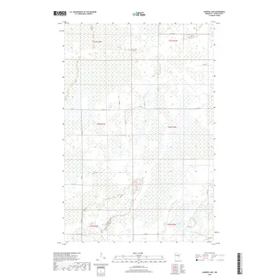
2019 Map of Sanders Lake
USGS Topo · Published 2019About this map
The Mississippi River curves through the southeastern corner of this Aitkin County landscape, defining the local drainage before it meets the Willow River. The terrain is characterized by an extensive network of wetlands and small water bodies, including Sanders Lake, which sits just north of the larger river's bend. This 2019 survey reflects a rural township structure dominated by the Public Land Survey System, with boundaries like t50n r24w and t49n r24w organizing the territory. Human presence is marked primarily by a grid of county infrastructure and local access points, such as Co Hwy 10 and Co Hwy 5, alongside numerous residential lanes like 578th Ln and 275th Pl. The map captures a contemporary look at this northern Minnesota environment where low-lying river bottoms and forested sections remain the primary geographic features.
Find a feature on this map
24 named features on this map. Tap any name to fly to it.
Don’t see what you’re looking for? This feature index may not catch every label — zoom into the map to look around manually.
Map Details
Editions of this 2019 Sanders Lake Map
This is the sole edition of this map. No revisions or reprints were ever made.
Other maps of this area

1914 · Aitkin
USGS Topo · 1:62,500

1915 · Aitkin
USGS Topo · 1:62,500

1953 · Duluth
USGS Topo · 1:250,000

1958 · Duluth
USGS Topo · 1:250,000

1970 · Rabey
USGS Topo · 1:24,000

1970 · Palisade
USGS Topo · 1:24,000

1970 · Sanders Lake
USGS Topo · 1:24,000
1970 · Ball Bluff
USGS Topo · 1:24,000

1970 · Libby
USGS Topo · 1:24,000
1970 · Minnewawa
USGS Topo · 1:24,000