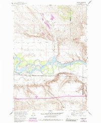
1960 Map of Sanders
USGS Topo · Published 1985About this map
The Yellowstone River dominates this landscape, winding through a complex system of islands and sandbars as it passes the small settlement of Sanders. The maps reveals an environment shaped by water management and transport, where the Yellowstone Canal and Hysham Canal flank the river to support agriculture in the Mission Valley. The Burlington Northern railroad corridor runs parallel to the southern bank, serving as the primary infrastructure artery for the region.
Find a feature on this map
16 named features on this map. Tap any name to fly to it.
Don’t see what you’re looking for? This feature index may not catch every label — zoom into the map to look around manually.
Map Details
Editions of this 1960 Sanders Map
2 editions found
Other maps of this area

1954 · Forsyth
USGS Topo · 1:250,000

1957 · Forsyth
USGS Topo · 1:250,000

1958 · Forsyth
USGS Topo · 1:250,000

1960 · Hysham
USGS Topo · 1:24,000

1960 · Vananda
USGS Topo · 1:24,000

1960 · Ahles
USGS Topo · 1:24,000

1960 · Sanders
USGS Topo · 1:24,000

1968 · Donleys Reservoir
USGS Topo · 1:24,000

1968 · Finch
USGS Topo · 1:24,000
1971 · Griffin Coulee NW
USGS Topo · 1:24,000