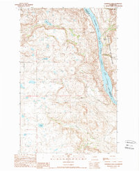
1989 Map of Sanderson Creek
USGS Topo · Published 1989About this map
Colville Indian Reservation land meets the eastern bank of the Columbia River-Rufus Woods Lake in this late-twentieth-century study of the boundary between Douglas and Okanogan Counties. The landscape is defined by the heavy drainage patterns of several seasonal and perennial waterways, including Sanderson Creek, Moses Creek, and China Creek, which carve through the plateau toward the river. High-country water bodies like Black Lake and Smith Lake are prominent landmarks within this sparsely developed terrain, where the absence of major towns highlights the importance of localized features like Schoolhouse Creek. The map records a specific moment in the river's history after the creation of Rufus Woods Lake, showing the relationship between the Reservation Boundary and the shoreline at Buckley Bar and Deep Canyon.
Find a feature on this map
16 named features on this map. Tap any name to fly to it.
Don’t see what you’re looking for? This feature index may not catch every label — zoom into the map to look around manually.
Map Details
Editions of this 1989 Sanderson Creek Map
2 editions found
Other maps of this area

1948 · Grand Coulee Dam
USGS Topo · 1:62,500

1950 · Grand Coulee Dam
USGS Topo · 1:62,500

1950 · Nespelem
USGS Topo · 1:62,500

1950 · Alameda Flat
USGS Topo · 1:62,500

1952 · Alameda Flat
USGS Topo · 1:62,500

1953 · Ritzville
USGS Topo · 1:250,000

1954 · Okanogan
USGS Topo · 1:250,000

1958 · Okanogan
USGS Topo · 1:250,000

1959 · Ritzville
USGS Topo · 1:250,000

1965 · Ritzville
USGS Topo · 1:250,000