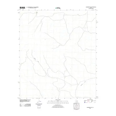
2010 Map of Sanderson NE
USGS Topo · Published 2010About this map
Brown Ranch sits at the northern edge of this arid expanse in Terrell County, representing the isolated ranching outposts that define the Trans-Pecos region. The landscape is dominated by the winding path of Eightmile Draw, an ephemeral watercourse that cuts through the terrain from the northwest to the southeast. This 2010 survey illustrates the sparse network of rural roads and four-wheel-drive tracks required to navigate this remote portion of Texas, where the economy remains tied to large landholdings and traditional cattle and sheep ranching. The absence of concentrated settlements highlights the rugged independence of this high-desert environment during the early 21st century.
Find a feature on this map
2 named features on this map. Tap any name to fly to it.
Don’t see what you’re looking for? This feature index may not catch every label — zoom into the map to look around manually.
Map Details
Editions of this 2010 Sanderson NE Map
This is the sole edition of this map. No revisions or reprints were ever made.
Other maps of this area

1928 · Sanderson
USGS Topo · 1:125,000

1954 · Fort Stockton
USGS Topo · 1:250,000

1958 · Fort Stockton
USGS Topo · 1:250,000

1969 · Sanderson SE
USGS Topo · 1:24,000

1969 · Sanderson
USGS Topo · 1:24,000

1969 · Big Canyon Ranch
USGS Topo · 1:24,000

1969 · Mofeta
USGS Topo · 1:24,000
1969 · Big Canyon Ranch SW
USGS Topo · 1:24,000
1969 · Hagler Canyon
USGS Topo · 1:24,000

1969 · Dryden NW
USGS Topo · 1:24,000