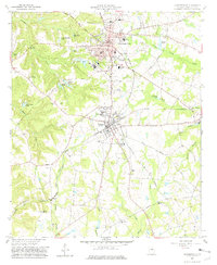
1962 Map of Sandersville
USGS Topo · Published 1981About this map
Sandersville and nearby Tennille serve as the primary hubs in this central Washington County landscape, where the Central of Georgia railroad creates a vital corridor through the rolling terrain. The map details an era of local industry and infrastructure, from the Jordan Mill in the northeast to several kaolin-related sites, including a mine and a settling basin west of the city. Notable for genealogists, the survey identifies numerous rural landmarks like the Brownwood Cem, Zeta Cem, and Elder High Sch. The intersection of agriculture and transit is evident along Savannah Road and near the Deep Cut Bridge over Sandy Creek. Small community congregations, such as Limestone Ch and Georgia Grove Ch, are scattered throughout the countryside, marking the established social fabric of this Georgia region during the early 1960s.
Find a feature on this map
62 named features on this map. Tap any name to fly to it.
Don’t see what you’re looking for? This feature index may not catch every label — zoom into the map to look around manually.
Map Details
Editions of this 1962 Sandersville Map
3 editions found

Other maps of this area

1953 · Athens
USGS Topo · 1:250,000

1957 · Macon
USGS Topo · 1:250,000

1958 · Macon
USGS Topo · 1:250,000

1958 · Athens
USGS Topo · 1:250,000

1959 · Athens
USGS Topo · 1:250,000

1961 · Deepstep
USGS Topo · 1:24,000

1961 · Warthen
USGS Topo · 1:24,000

1962 · Oconee
USGS Topo · 1:24,000

1962 · Irwins Crossroads
USGS Topo · 1:24,000

1962 · Tabernacle
USGS Topo · 1:24,000