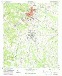
1962 Map of Sandersville
USGS Topo · Published 1986About this map
The industrial and agricultural landscape of Washington County comes into focus on this survey, centered on the historic regional hub of Sandersville and its neighbor Tennille. A significant geographic feature is the extensive Kaolin Field and associated Kaolin deposits, illustrating the area's importance to the global clay mining industry. The Central of Georgia railroad provides the backbone for transportation, connecting these industrial sites to the wider region. Beyond the urban centers, the map documents a network of rural community landmarks, including Elder High School and several family-named water bodies like Anderson Pond and Harrison Pond. Local history is preserved in the locations of Brownwood Cemetery and Sisters Church, while the presence of a Cannery and Fish Hatchery points to the diverse mid-century local economy.
Find a feature on this map
57 named features on this map. Tap any name to fly to it.
Don’t see what you’re looking for? This feature index may not catch every label — zoom into the map to look around manually.
Map Details
Editions of this 1962 Sandersville Map
3 editions found

Other maps of this area

1953 · Athens
USGS Topo · 1:250,000

1957 · Macon
USGS Topo · 1:250,000

1958 · Macon
USGS Topo · 1:250,000

1958 · Athens
USGS Topo · 1:250,000

1959 · Athens
USGS Topo · 1:250,000

1961 · Deepstep
USGS Topo · 1:24,000

1961 · Warthen
USGS Topo · 1:24,000

1962 · Oconee
USGS Topo · 1:24,000

1962 · Irwins Crossroads
USGS Topo · 1:24,000

1962 · Tabernacle
USGS Topo · 1:24,000