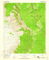
1954 Map of Sandia Crest
USGS Topo · Published 1959About this map
The Sandia Mountains dominate this mid-century survey, revealing a landscape defined by the convergence of Spanish land grant boundaries and modern recreation. The western slopes are divided between the Sandia Pueblo Grant and the Elena Gallegos Grant, highlighting the complex colonial and indigenous land tenure that persisted well into the 1950s. Near the summit, the presence of Radio and TV Towers at Sandia Crest marks the era’s technological expansion above the traditional trails.
Find a feature on this map
64 named features on this map. Tap any name to fly to it.
Don’t see what you’re looking for? This feature index may not catch every label — zoom into the map to look around manually.
Map Details
Editions of this 1954 Sandia Crest Map
2 editions found
Other maps of this area

1888 · Bernalillo
USGS Topo · 1:125,000

1889 · Albuquerque
USGS Topo · 1:125,000

1892 · San Pedro
USGS Topo · 1:125,000

1893 · Albuquerque
USGS Topo · 1:125,000

1934 · Alameda
USGS Topo · 1:24,000

1934 · East Albuquerque
USGS Topo · 1:24,000

1938 · Albuquerque
USGS Topo · 1:62,500

1954 · Sandia Crest
USGS Topo · 1:24,000

1954 · Alameda
USGS Topo · 1:24,000

1954 · Placitas
USGS Topo · 1:24,000
Featured Places
- Albuquerque, NM
- Cedar Crest, NM
- Evergreen Hills Subdivision, NM
- Cooper LS Ranch, NM
- Glenwood Hills, Albuquerque