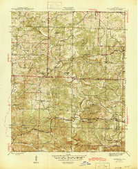
1943 Map of Sandtown
USGS Topo · Published 1945About this map
Polk Bayou and Barren Fork carve through this section of the Ozark foothills, where small agrarian settlements and scattered mining operations defined the landscape during the 1940s. The map captures a community structured around rural institutions, with centers like Sidney and Sandtown serving as local hubs. The upland terrain is dotted with schools and churches, including Liberty Sch, Conyers Spring Sch, and St Pauls Ch, reflecting the dispersed nature of early 20th-century settlement in Independence and Sharp counties.
Find a feature on this map
55 named features on this map. Tap any name to fly to it.
Don’t see what you’re looking for? This feature index may not catch every label — zoom into the map to look around manually.
Map Details
Editions of this 1943 Sandtown Map
4 editions found
Other maps of this area

1890 · Batesville
USGS Topo · 1:125,000

1891 · Batesville
USGS Topo · 1:125,000

1942 · Bethesda
USGS Topo · 1:24,000

1942 · Batesville
USGS Topo · 1:31,680

1942 · Mt Pleasant
USGS Topo · 1:31,680

1943 · Sandtown
USGS Topo · 1:24,000

1943 · Cave City
USGS Topo · 1:31,680

1943 · Sulphur Rock
USGS Topo · 1:31,680

1943 · Batesville
USGS Topo · 1:24,000

1951 · Melbourne
USGS Topo · 1:62,500