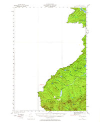
1927 Map of Sandy Bay
USGS Topo · Published 1964About this map
Hilton Farm and Sandy Bay Farm occupy a narrow corridor of cleared land along the international border in this 1927 survey. The landscape is defined by the headwaters of the Penobscot River South Branch, which winds through the townships of Sandy Bay T 5 R 3 and Prentiss T 4 R 4. This northern wilderness, mapped by R. J. Belton and the International Boundary Commission, reveals a territory structured by water and timber, with camps like South Branch Camp and notable water features such as Little Canada Falls. The topography is dominated by massive landforms including Bald Mountain and Moose Mtn, while the irregular boundary with Quebec follows the high ridgeline and numerous alpine waters like Fisher Ponds and Cape Horn Pond.
Find a feature on this map
35 named features on this map. Tap any name to fly to it.
Don’t see what you’re looking for? This feature index may not catch every label — zoom into the map to look around manually.
Map Details
Editions of this 1927 Sandy Bay Map
5 editions found
Other maps of this area

1922 · Long Pond
USGS Topo · 1:62,500

1923 · Attean
USGS Topo · 1:62,500

1924 · Long Pond
USGS Topo · 1:62,500

1925 · Attean
USGS Topo · 1:62,500

1927 · Sandy Bay
USGS Topo · 1:48,000

1928 · Skinner
USGS Topo · 1:48,000

1930 · Sandy Bay
USGS Topo · 1:62,500

1931 · Skinner
USGS Topo · 1:62,500

1944 · Long Pond
USGS Topo · 1:62,500

1944 · Sandy Bay
USGS Topo · 1:62,500