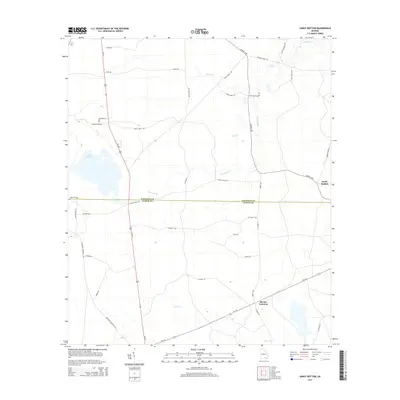
2014 Map of Sandy Bottom
USGS Topo · Published 2014About this map
Guest Millpond dominates the western landscape of this South Georgia quadrangle, where the boundary between Atkinson Co and Clinch Co divides the piney woods and wetlands. This area, documented in 2014, is characterized by a network of drainage systems including Red Bluff Cr, Cane Cr, and Stump Cr. The settlement patterns are concentrated around rural junctions like Sandy Bottom and Mexico Crossing, linked by a web of local roads that carry significant historical names. Traces of older transport routes are visible through labels like Stage Coach Rd and Mizell Bridge Rd, which hint at the region's traditional connectivity. The presence of Red Bluff Church Rd and various family-named lanes such as Joe Nugent Rd and Betty Smith Rd points to a landscape deeply tied to local genealogy and established land tracts.
Find a feature on this map
37 named features on this map. Tap any name to fly to it.
Don’t see what you’re looking for? This feature index may not catch every label — zoom into the map to look around manually.
Map Details
Editions of this 2014 Sandy Bottom Map
This is the sole edition of this map. No revisions or reprints were ever made.
Other maps of this area

1953 · Waycross
USGS Topo · 1:250,000

1958 · Waycross
USGS Topo · 1:250,000

1968 · Homerville East
USGS Topo · 1:24,000

1968 · Cogdell
USGS Topo · 1:24,000

1971 · Axson
USGS Topo · 1:24,000

1971 · Pearson
USGS Topo · 1:24,000

1972 · Kirkland
USGS Topo · 1:24,000

1972 · Sirmans
USGS Topo · 1:24,000

1972 · Sandy Bottom
USGS Topo · 1:24,000

1972 · Henderson Still
USGS Topo · 1:24,000