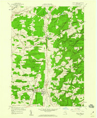
1958 Map of Sandy Creek
USGS Topo · Published 1960About this map
The New York Central Railroad corridor serves as the industrial spine of this northern New York landscape, connecting the clustered settlements of Lacona, Sandy Creek, and Mannsville. This late-1950s survey captures a transition in rural life, where long-established crossroads like Pierrepont Manor and Ellisburg sit alongside a sprawling State Reforestation Area in the east. Local history is deeply etched into the topography, from the Fairground near the creek to family-named markers like Torrey Hill and the Brewster Cem.
Find a feature on this map
55 named features on this map. Tap any name to fly to it.
Don’t see what you’re looking for? This feature index may not catch every label — zoom into the map to look around manually.
Map Details
Editions of this 1958 Sandy Creek Map
4 editions found
Other maps of this area

1893 · Sackets Harbor
USGS Topo · 1:62,500

1895 · Sacketts Harbor
USGS Topo · 1:62,500

1895 · Pulaski
USGS Topo · 1:62,500

1895 · Watertown
USGS Topo · 1:62,500

1898 · Watertown
USGS Topo · 1:62,500

1903 · Orwell
USGS Topo · 1:62,500

1905 · Orwell
USGS Topo · 1:62,500

1908 · Watertown
USGS Topo · 1:62,500

1909 · Watertown
USGS Topo · 1:62,500

1942 · Sandy Creek
USGS Topo · 1:24,000