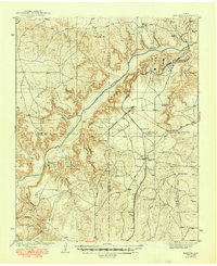
1939 Map of Sanford
USGS Topo · Published 1949About this map
The Canadian River carves a deep path through the Texas Panhandle in this survey, defining a landscape dominated by large cattle ranches and the burgeoning petroleum industry. Numerous family-named homesteads and operations, such as the Ingerton Ranch, McBride Ranch, and Poling Ranch, are spread across the broken terrain and canyons. The arrival of the Chicago Rock Island and Gulf railroad through Sanford and Fritch highlights the era's transport network, connecting these remote outposts to broader markets.
Find a feature on this map
48 named features on this map. Tap any name to fly to it.
Don’t see what you’re looking for? This feature index may not catch every label — zoom into the map to look around manually.
Map Details
Editions of this 1939 Sanford Map
2 editions found
Other maps of this area

1934 · Cliffside
USGS Topo · 1:62,500

1936 · Fourways
USGS Topo · 1:62,500

1936 · Cliffside
USGS Topo · 1:62,500

1939 · Sanford
USGS Topo · 1:62,500

1953 · Sanford
USGS Topo · 1:24,000

1953 · Chunky
USGS Topo · 1:24,000

1953 · Alibates Ranch
USGS Topo · 1:24,000

1953 · Stinnett
USGS Topo · 1:24,000

1953 · Evans Canyon
USGS Topo · 1:24,000

1953 · Deal
USGS Topo · 1:24,000