
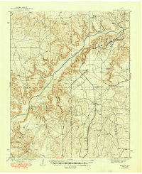
1939 Map of Sanford
USGS Topo · Published 1939About this map
The Canadian River cuts a deep diagonal through the Panhandle landscape, where high plains give way to the complex drainage of McBride Canyon and Mortons Canyon. Surveyed in the mid-1930s, this area reflects the intersection of traditional Texas ranching and the burgeoning petroleum industry. The small community of Sanford sits near the river, while the presence of Oil City to the northeast highlights the regional energy boom that transformed the territory during this era.
Find a feature on this map
45 named features on this map. Tap any name to fly to it.
Don’t see what you’re looking for? This feature index may not catch every label — zoom into the map to look around manually.
Map Details
Editions of this 1939 Sanford Map
2 editions found
Other maps of this area

1934 · Cliffside
USGS Topo · 1:62,500

1936 · Fourways
USGS Topo · 1:62,500

1936 · Cliffside
USGS Topo · 1:62,500

1953 · Sanford
USGS Topo · 1:24,000

1953 · Chunky
USGS Topo · 1:24,000

1953 · Alibates Ranch
USGS Topo · 1:24,000

1953 · Stinnett
USGS Topo · 1:24,000

1953 · Evans Canyon
USGS Topo · 1:24,000

1953 · Deal
USGS Topo · 1:24,000

1953 · McDowell Creek
USGS Topo · 1:24,000