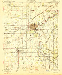
1947 Map of Sanger
USGS Topo · Published 1947About this map
Sanger and Del Rey anchor this mid-century portrait of Fresno County’s agricultural heartland, where a complex network of irrigation ditches and canals sustains the landscape. The Kings River flows along the eastern edge, feeding an intricate system of waterworks including the Switch Canal, Hansen Ditch, and Gould Ditch. This infrastructure, vital to the region's orchard and vineyard economy, is mirrored by the dense grid of rural avenues like Ventura Avenue and Jensen Avenue. Two major rail lines, the Southern Pacific and the Atchison Topeka and Santa Fe, provide the necessary transit for local produce. The map preserves the locations of several rural social centers, including Salem Ch, Granville Sch, and Prairie Sch, which served the scattered farming families of the Sanger district.
Find a feature on this map
60 named features on this map. Tap any name to fly to it.
Don’t see what you’re looking for? This feature index may not catch every label — zoom into the map to look around manually.
Map Details
Editions of this 1947 Sanger Map
2 editions found
Other maps of this area

1920 · Orangedale School
USGS Topo · 1:24,000

1922 · Round Mountain
USGS Topo · 1:31,680

1922 · Trimmer
USGS Topo · 1:96,000

1923 · Malaga
USGS Topo · 1:31,680

1923 · Orangedale School
USGS Topo · 1:31,680

1923 · Clovis
USGS Topo · 1:31,680

1923 · Wahtoke
USGS Topo · 1:31,680

1923 · Sanger
USGS Topo · 1:31,680

1924 · Reedley
USGS Topo · 1:31,680

1924 · Selma
USGS Topo · 1:31,680