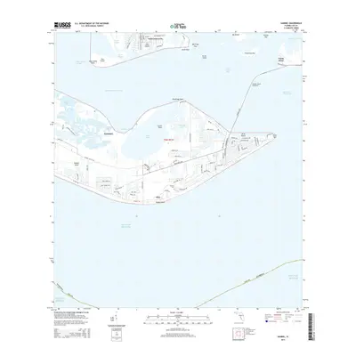
2015 Map of Sanibel
USGS Topo · Published 2015About this map
Sanibel and its intricate shoreline are documented here during a period of established coastal development. The Sanibel Island Causeway provides a vital link across San Carlos Bay from Punta Rassa, connecting the mainland to the island's interior road network along Periwinkle Way and Sanibel-Captiva Rd. To the north, Saint James City on Pine Island shows a dense grid of canals, including Monroe Canal and Phillips Canal, illustrating the region's engineered maritime residential landscape. The map reveals the island's unique geography, from the interior waters of Tarpon Bay and Ladyfinger Lake to the southern beaches at Ybel and Dixie Beach. Local landmarks like Sanibel Cem and several family-named roads provide significant data points for genealogical research and local history studies in Lee County.
Find a feature on this map
87 named features on this map. Tap any name to fly to it.
Don’t see what you’re looking for? This feature index may not catch every label — zoom into the map to look around manually.
Map Details
Editions of this 2015 Sanibel Map
This is the sole edition of this map. No revisions or reprints were ever made.
Other maps of this area

1956 · West Palm Beach
USGS Topo · 1:250,000

1956 · Tampa
USGS Topo · 1:250,000

1956 · Charlotte Harbor
USGS Topo · 1:250,000

1957 · West Palm Beach
USGS Topo · 1:250,000

1958 · West Palm Beach
USGS Topo · 1:250,000

1958 · Captiva
USGS Topo · 1:24,000

1958 · Fort Myers SW
USGS Topo · 1:24,000

1958 · Sanibel
USGS Topo · 1:24,000

1958 · Pine Island Center
USGS Topo · 1:24,000
1958 · Wulfert
USGS Topo · 1:24,000
Featured Places
- Sanibel, FL
- Saint James Mobile Home Park, FL
- Ybel, Sanibel
- Punta Rassa Condos, Punta Rassa
- Saint James City, FL