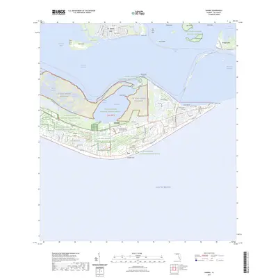
2024 Map of Sanibel
USGS Topo · Published 2024About this map
Sanibel Island serves as the focal point of this coastal survey, where the balance between conservation and community development is clearly visible. Large portions of the island are dedicated to the J N Ding Darling National Wildlife Refuge and the J N "Ding" Darling Wilderness, protecting the wetlands and mangroves around Tarpon Bay. The map documents the residential road network stretching from Point Ybel in the east toward the nature preserves in the west, with local history preserved at the Saint Michael and All Angels Episcopal Church Cem and the Sanibel Historic Cem. To the north, across the San Carlos Bay, the southern tip of Pine Island is marked by St. James City, while the mainland side at Punta Rassa shows the gateway to the Intracoastal Waterway and Okeechobee Waterway.
Find a feature on this map
93 named features on this map. Tap any name to fly to it.
Don’t see what you’re looking for? This feature index may not catch every label — zoom into the map to look around manually.
Map Details
Editions of this 2024 Sanibel Map
This is the sole edition of this map. No revisions or reprints were ever made.
Other maps of this area

1956 · West Palm Beach
USGS Topo · 1:250,000

1956 · Tampa
USGS Topo · 1:250,000

1956 · Charlotte Harbor
USGS Topo · 1:250,000

1957 · West Palm Beach
USGS Topo · 1:250,000

1958 · West Palm Beach
USGS Topo · 1:250,000

1958 · Captiva
USGS Topo · 1:24,000

1958 · Fort Myers SW
USGS Topo · 1:24,000

1958 · Sanibel
USGS Topo · 1:24,000

1958 · Pine Island Center
USGS Topo · 1:24,000
1958 · Wulfert
USGS Topo · 1:24,000
Featured Places
- Sanibel, FL
- Saint James Mobile Home Park, FL
- Ybel, Sanibel
- Punta Rassa Condos, Punta Rassa
- Saint James City, FL