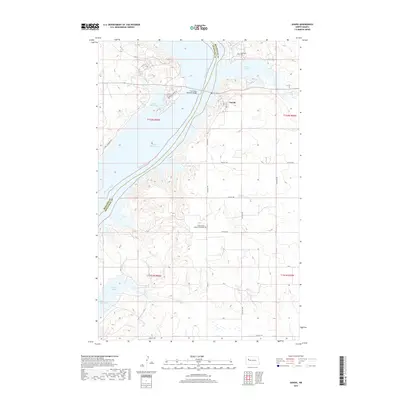
2017 Map of Sanish
USGS Topo · Published 2017About this map
Lake Sakakawea dominates this landscape where the Missouri River once flowed unimpeded between McKenzie and Mountrail counties. The modern shoreline is deeply indented by prominent inlets like Four Bears Bay and Reunion Bay, reflecting the transformative impact of mid-century damming on the Missouri basin. The settlement of Sanish is situated on the eastern bluffs overlooking Sanish Bay, connected across the water by the Four Bears Memorial Bridge. Land use is defined by a rigorous grid of section roads, including 32nd St NW and 90th Ave NW, which navigate the high ground around the reservoir. For local historians, the map identifies significant sites such as the Grand Valley Lutheran Cemetery and Riverview Cem, preserved on the heights above the rising waters that altered the region's geography.
Find a feature on this map
32 named features on this map. Tap any name to fly to it.
Don’t see what you’re looking for? This feature index may not catch every label — zoom into the map to look around manually.
Map Details
Editions of this 2017 Sanish Map
This is the sole edition of this map. No revisions or reprints were ever made.
Other maps of this area

1953 · Williston
USGS Topo · 1:250,000

1953 · Watford City
USGS Topo · 1:250,000

1957 · Williston
USGS Topo · 1:250,000

1957 · Watford City
USGS Topo · 1:250,000

1967 · Watford City
USGS Topo · 1:250,000

1967 · Sanish NW
USGS Topo · 1:24,000

1967 · Sanish
USGS Topo · 1:24,000

1967 · Sanish SE
USGS Topo · 1:24,000

1967 · New Town SW
USGS Topo · 1:24,000

1967 · Sanish SW
USGS Topo · 1:24,000