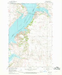
1967 Map of Sanish
USGS Topo · Published 1969About this map
Lake Sakakawea dominates this Missouri River Basin landscape, reflecting the significant geographic changes following the completion of the Garrison Dam. The settlement of Sanish sits along the northern shores of Sanish Bay, adjacent to the Soo Line railroad. This survey captures a moment when the regional infrastructure was adapting to the new reservoir, highlighted by the Four Bears Memorial Bridge crossing the water toward the Fort Berthold Indian Reservation Boundary.
Find a feature on this map
24 named features on this map. Tap any name to fly to it.
Don’t see what you’re looking for? This feature index may not catch every label — zoom into the map to look around manually.
Map Details
Editions of this 1967 Sanish Map
2 editions found
Other maps of this area

1953 · Williston
USGS Topo · 1:250,000

1953 · Watford City
USGS Topo · 1:250,000

1957 · Williston
USGS Topo · 1:250,000

1957 · Watford City
USGS Topo · 1:250,000

1967 · Watford City
USGS Topo · 1:250,000

1967 · Sanish NW
USGS Topo · 1:24,000

1967 · Sanish
USGS Topo · 1:24,000

1967 · Sanish SE
USGS Topo · 1:24,000

1967 · New Town SW
USGS Topo · 1:24,000

1967 · Sanish SW
USGS Topo · 1:24,000