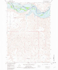
1956 Map of Sansarc NE
USGS Topo · Published 1982About this map
The Cheyenne River winds through this central South Dakota landscape, defining the border between Dewey and Stanley counties. This 1956 field check occurs during a transformative period for the Missouri River Basin; dashed light-blue patterns indicate areas destined to be submerged by the Oahe Reservoir at an elevation flood control pool of 1617 feet. The map documents the existing ranching economy before the rising waters altered the shoreline, featuring family operations such as the Vanderveer Ranch, Sunshine Ranch, and West Ranch along the riverbanks. High plateaus like Kid Rich Flats and Marion Flats overlook the drainage of Foster Creek. Cultural sites are concentrated on the northern banks within the Cheyenne River Indian Reservation, including Walking Horse Cem and Lindsay Cem, providing critical data for genealogists tracking family burials in areas affected by mid-century water management projects.
Find a feature on this map
14 named features on this map. Tap any name to fly to it.
Don’t see what you’re looking for? This feature index may not catch every label — zoom into the map to look around manually.
Map Details
Editions of this 1956 Sansarc NE Map
3 editions found
Other maps of this area

1954 · Pierre
USGS Topo · 1:250,000

1956 · Alleman Station
USGS Topo · 1:24,000

1956 · Rousseau Creek SW
USGS Topo · 1:24,000

1956 · Herbert Creek SE
USGS Topo · 1:24,000

1956 · Sansarc NE
USGS Topo · 1:24,000

1956 · Crockett Mountains
USGS Topo · 1:24,000

1958 · Pierre
USGS Topo · 1:250,000

1981 · Herbert Creek SW
USGS Topo · 1:24,000

1982 · Sansarc
USGS Topo · 1:24,000

1982 · Whiteman Ranch
USGS Topo · 1:24,000