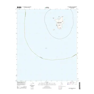
2015 Map of Santa Barbara Island
USGS Topo · Published 2015About this map
Santa Barbara Island sits isolated within the Pacific Ocean, its steep-sided profile and sharp canyons meticulously charted in this topographic study. As part of Channel Islands National Park, the island's geography is defined by prominent coastal markers like Webster Point and Arch Point, alongside deep incisions such as Cave Canyon and Cat Canyon. The terrain rises to its highest elevation at Signal Peak, overlooking a coastline punctuated by small offshore features like Shag Rock. Marine life habitats are noted through labels like Elephant Seal Cove, while maritime access is centered at Landing Cove. The map provides an essential look at the physical isolation and natural preservation of the southernmost of the Channel Islands, showing the intricate relationship between the island's volcanic geology and the surrounding marine environment.
Find a feature on this map
13 named features on this map. Tap any name to fly to it.
Don’t see what you’re looking for? This feature index may not catch every label — zoom into the map to look around manually.
Map Details
Editions of this 2015 Santa Barbara Island Map
This is the sole edition of this map. No revisions or reprints were ever made.
Other maps of this area

1949 · Long Beach
USGS Topo · 1:250,000

1957 · Long Beach
USGS Topo · 1:250,000

1958 · Long Beach
USGS Topo · 1:250,000

1960 · Long Beach
USGS Topo · 1:250,000
1981 · Santa Catalina Island
USGS Topo · 1:100,000
1981 · Long Beach
USGS Topo · 1:100,000
1984 · Laguna Harbor
USGS Topo · 1:100,000
1993 · San Nicolas Island
USGS Topo · 1:100,000
2012 · Santa Barbara Island
USGS Topo · 1:24,000
2012 · Santa Barbara Island OE N
USGS Topo · 1:24,000